
|
Arborfield
|
|
Properties
Related sites:
Reading Road and Walden Avenue Swallowfield Road, White's and Bartlett's Farms Duck's Nest Farm and Eversley Road
Modern aerial photo of Arborfield Cross, courtesy of Multimap
|
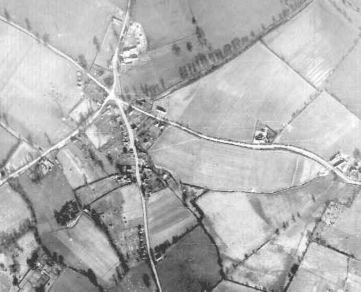
Detail from RAF aerial photo of part of the parishes of Arborfield and Newland, dated 10th March 1946, ref. 3040, reproduced by permission of the National Monuments Record, English Heritage.
This close-up of Arborfield Cross is not as clear as the example taken on 10th July, but it is evident that the trees and houses are casting very long shadows in the clear sunlight. Eversley Road branches southwards from the five-way cross-roads with Hillcrest near the bottom of the picture. School Road branches off to the right; the school itself occupies only a small piece of land, and surrounded by fields. At the extreme right is Langley Pond Farm. The large field to the south of School Road was compulsorily purchased later in 1946, and became Anderson and Emblen Crescents by 1952, while Link Way remained as fields until 1960. Swallowfield Road is to the left; note how few houses are on Swallowfield Road, and the complete absence of houses behind Eversley Road; however, the shape of the future Melrose Gardens can be seen in the field pattern.
In October 1946, Berkshire County Council's Highways and Bridges
committee had been presented with a long list of proposals to by-pass
towns and villages including: ‘A by-pass of the Reading – Eversley
Road (A327) commencing at a point west of Arborfield Cross to rejoin it
at a point to the south thereof. This is necessary in order to avoid
development at Arborfield’. This by-pass remained an active
consideration when the Chamberlains estate was started in the early
1960's. At the back of No. 2 Chamberlain Gardens was an electricity
sub-station intended to serve a new estate to be built to the south of
Melrose Gardens and enclosed by the by-pass. It was finally declared
redundant a quarter of a century later when the by-pass was considered a
non-starter.
A further close-up of the aerial photo gives a good view of the pond at the five-way cross-roads, as shown on the right.
Compared with the aerial photo from July 1946, it seems that there are
either temporary buildings, or
Any information about these temporary buildings, whatever they are, would be gratefully received.
Back to Aerial Photos main page
|
|||
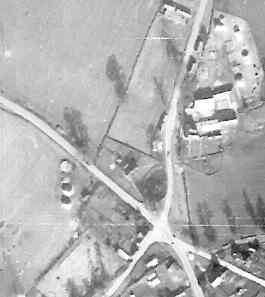
 tents,
or haystacks, in the field to the west of the 'Bull', because they are not in the close-up
from July as shown on the
left.
tents,
or haystacks, in the field to the west of the 'Bull', because they are not in the close-up
from July as shown on the
left. |
Any Feedback or comments on this website? Please e-mail the webmaster |