
|
Arborfield
|
|
Properties
Related sites:
Map showing the
effect of the railway on the |
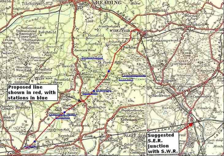
Arborfield and surrounding villages might have been quite different if a proposed railway had been built. By 1895, the main railway routes in the area were long-established. There were three routes to London from Reading; the G.W.R. to Paddington, the S.E.R. to London Bridge via Guildford, and the S.W.R. to Waterloo via Ascot, branching off from the S.E.R. at Wokingham. Much further south was the fast S.W.R. line from Basingstoke to Waterloo via Farnborough. Those living close to the stations could reach London in just over an hour, but villagers faced a long horse-drawn journey by carriage or cart to reach the nearest station. Frustrations reached boiling point by 1895, when lengthy correspondence between Sandhurst Parish Council and the South Eastern Railway was published in the 'Reading Mercury' of 7th September. The Council had requested a junction between the Guildford line and the South-Western main line at Farnborough, but the S.E.R. kept coming up with excuses, because of course they didn't want to lose their passengers to a rival. To complicate matters, the chairman of the S.E.R. was Sir George Russell, Bart., who also happened to be the M.P. for Wokingham. He lived at Swallowfield Park. There was a long-standing irritation at the delays caused at Wokingham, as reported in the 'Mercury' of 25th January 1896: "At the meeting of the Wokingham Town Council last week, a letter was read by the Town Clerk which he had received from the Secretary of the South Eastern Railway in reply to a letter and resolutions recently forwarded to Sir George Russell, the Chairman of the Company, with reference to the inconvenient and dangerous level crossing near the railway station. In the letter it was suggested that Sir George Russell and some of his colleagues should meet some of the members of the Wokingham Corporation at the level crossing and hear what they had to say on the subject; arrangements could then be made for a meeting to be held in London to consider what is best to be done in the matter. It was accordingly agreed that a committee consisting of the Mayor, the Ex-Mayor, Ald. Wescott and Ald. Heron should arrange to meet Sir George and the Directors of the South Eastern Railway as suggested." Against this background, it is not surprising that a new railway was being promoted to link Basingstoke and Wokingham, providing access to a string of villages south and west of Arborfield. The proposed line would go under the Arborfield - Eversley Cross road, and there was to be a station serving both Eversley and Finchampstead. The line would have passed through land later occupied by Arborfield Garrison. There is a map of the proposed railway at Berkshire Record Office, along with sectional drawings of the entire route, and a detailed list of land-holdings and their owners and occupiers by Parish. The route was drawn on a very old Ordnance Survey map, where all roads and lanes were either dirt tracks or gravel. Click here to see the old map.
Here's the proposed route, drawn on a more modern but out-of-copyright Ordnance
Survey map from the early 1920s:
The 'Mercury' was strongly in favour of the proposed railway, as quoted on 25th January 1896: "The unanimous resolutions
passed at the meetings of both the Basingstoke and Wokingham Urban
District Councils conclusively prove the popularity of the project for
joining Basingstoke and Wokingham by a direct line of railway which will
not only form the connecting link between the main line of the London
and South Western Railway and their Staines and Wokingham branch, but
will also be of very great advantage to the intermediate district, which
is now badly provided with railway accommodation. The line was never built, but if it had been, it would have altered the development of Arborfield in the early 20th Century. Map - Ordnance Survey Quarter-Inch 1922 Edition, O.S. by acknowledgement. Route copied from a map and plans held at Berkshire Record Office, ref. 'Q/RUm 208'.
The same issue of the 'Mercury' (25th January 1896) reported the Council meetings in more detail: THE PROPOSED NEW RAILWAY FROM WOKINGHAM TO BASINGSTOKE. MEETING AT WOKINGHAM TOWN COUNCIL: A special meeting of the Wokingham Town Council was held on the 18th inst., to consider the question of the proposed new Railway from Basingstoke to Wokingham. The MAYOR (Mr. E. IFOULD) presided, and others present included: Aldermen T. W. Heelas, T. M. Wescott, D. Heron and W. White; Councillors Phillips (ex-Mayor), Headington, Mower, Powell, Frith, F. Sale, G. Sale, Knight, Drake, and Stone; the Town Clerk (Mr. J. May), and the Borough Surveyor (Mr. Walton). The MAYOR opened the proceedings by explaining the object of the meeting. He explained the benefits it would confer upon the trade of the town. It would also make it easier for the Council to obtain coal from Southampton for the Gas works. He also alluded to inconvenient and dangerous level crossing near the Station, which he hoped would be altered, or perhaps they might get a bridge erected over the line near the cricket field. A further advantage of the new line would be that it would enable the people of Wokingham to attend the markets at Basingstoke. A letter was read from the solicitor to the proposed new railway (Messrs. Mathews, Browne, and Co., of Cannon-street, E.C.) asking the Council to pass resolutions in support of the scheme. A representative (Mr. White) from Messrs. Mathews, Browne, and Co’s offices shortly afterwards entered the Council Chamber, accompanied by Mr. Arthur C. Pain, of Victoria-street, Westminster, the engineer to the suggested line. At the request of the Mayor, Mr. Pain explained to the Council the line of route it was proposed the railway should take. He mentioned that the length of the line would be about 14½ miles from the L. and S. W. R. Station at Basingstoke to Wokingham. The line of route would be by Basing, Sherfield-on-Loddon, Hartley Wespall, Heckfield, Eversley, Finchampstead, to Wokingham. The cost would be about £185,000. It was likely to be of great benefit to the district, and would tend greatly to the development of that part of the country. The promoters, when the project was first suggested, communicated with the late Mr. John Walter, through whose land it had been intended that the line should pass. He (Mr. Pain) believed that Mr. A. F. Walter would recognise the advantages the district would derive from the railway. Eventually the line would become part of the S.W.R. In the first instance a single line of rails would be laid down, but sufficient land would be purchased to allow of a double line. After some discussion as to whether the new line would cause a further obstruction of traffic at the level crossing:
A further resolution asking the High Steward of Wokingham to use his influence in favour of the undertaking was moved by Councillor POWELL, seconded by Ald. Wescott, and also carried unanimously. MEETING AT BASINGSTOKE. Mr. A. C. Pain, of Frimley and Victoria-street, Westminster, the engineer who has prepared the plans of the proposed New Railway between Basingstoke and Wokingham, also attended the meeting of the Basingstoke Town Council last week (on the 13th) and laid the plans before the members of that Council, and explained the line of route it was proposed the railway should take. The Mayor of Basingstoke (Ald. Tigwell) presided at the meeting, and amongst the other members of the Corporation present were Aldermen Wadmore, Powell and Follett, Councillors Simmons, Phillips, Kingdon, Bird, Smith, Edney, Tyrrell, Glanville and Julian. A representative from Messrs. F. C. Mathews, Browne and Co. (of Cannon-street), the Solicitors to the Railway, also attended and had an interview with the Council. Mr. A. C. Pain, C.E., said the proposed railway would open up for residential and other purposes a large area of land in a most beautiful part of the county and would provide an alternative route to London, only four miles longer than the present route to Waterloo. They had received very gratifying support from the landowners through the district in which the railway would pass. They proposed buying land sufficient for a double line, but only laying a single one at present. The estimated cost was £184,789. The line would run out of the London and South-Western railway at Wokingham and into it again at Basingstoke, and must in time become an integral part of the South-Western system. It was proposed that there should be five stations, one at Basing; one at Sherfield-on-Loddon; one for Heckfield and Bramshill; one for Finchampstead and Eversley; and one for Swallowfield; but it was the directors’ intention to place as many stations as would be consistent with the needs of the district. Up to the present time they had no legal notice of opposition from the London and South-Western Railway. After some discussion the following resolution was proposed by Alderman Follett, and seconded by Councillor Glanville: "That this Council, having considered the projected Basingstoke and Wokingham Railway, are of the opinion that its construction will be of great benefit to the town and trade of Basingstoke and district, and that the clerk be instructed to ask Mr. Jeffreys, M.P., to support the Bill in Parliament". This was carried unanimously. It was then moved by Councillor Simmons, and seconded by Councillor Kingdon, "That the Council having considered the proposed Basingstoke and Wokingham Railway, are of the opinion that its construction will be of such great local and public advantage, that the clerk is hereby instructed to draw the attention of the directors of the London and South-Western Railway Company to the improved means of communication which the line will afford, and to express the hope of the Council that the Company will see their way to support the Bill". This resolution was also carried unanimously.
The following week, the 'Mercury' reported Berkshire County Council's Highways and Bridges Committee meeting, where it was stated that "The proposed line would pass beneath the main road leading from Arborfield to Eversley Bridge". It was reported: "The Committee recommend the Council to dissent from the proposal, on the ground that the plans deposited are not satisfactory to the Committee as road and bridge authority, but that the Clerk be instructed to withdraw the dissent in the event of the plans being amended to the satisfaction of the County Surveyor."
The proposed railway never made it into Parliament. We can only guess why, because there's nothing in the contemporary press to tell us. Here is one possibility:
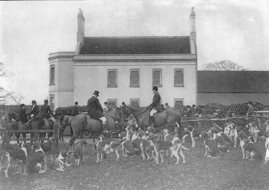
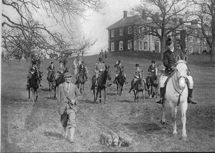
John Hayes Simonds was aged 21 in 1895, and was a very keen horse-rider, often taking a leading part in the Garth Hunt's Point-to-Point races later held at the Remount Depot. Four major landowners listed in the proposal document were also strongly connected with fox-hunting: His Grace, the Duke of Wellington; Sir Anthony Cope, Bart., of Bramshill; William Simonds, of Farley Hill (the brother of John Simonds of Newlands); Major Arthur Fraser Walter, of Bearwood. The following extract from the 'Reading Mercury' of March 20th 1897 showed that hunting and railways don't mix: HUNTING NOTES: MR. GARTH’S: Bearwood Lodge on the 8th, when a large field was out and they had a nailing days sport. Hounds found in Bottle Copse, running straight for the Brick-yard, bearing away to the left, over the Barkham-road, by the Lodges, swinging again a bit left, away to Sindlesham, but being headed he popped back over the S.E.R. [South Eastern Railway] into King-street gorse, where hounds had a narrow squeak from a train, but the engine driver pulled up on time to avoid damage – for which many thanks to him. [...]
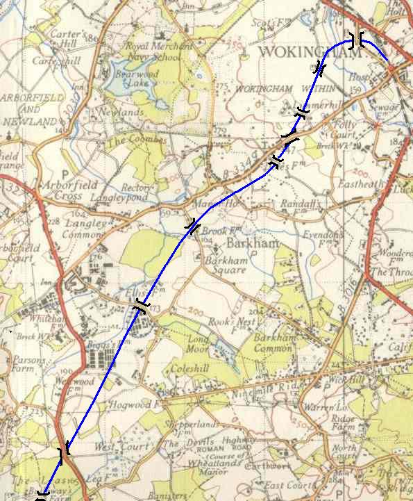
What effect would the railway have had on the Arborfield area? This O.S. one-inch map from around 1950 shows the proposed route in more detail. The table beneath it gives details of bridges and inclines, and shows that the embankments and cuttings would have had a marked effect on the areas that the line passed. The detailed strip-maps were based on the 6-inch Ordnance Survey, show a slightly different route at Edneys Hill and Barkham Street than on the outline map; the line is further north on the detailed map, as shown here:
Bridges from the River Blackwater to Wokingham are shown on the table below; there were no bridges listed for the Barkham Brook or the Emmbrook; they were likely to have been culverts rather than bridges [Note: The 'Cross Sections' listed in the table are shown in the original documents, and are not on this web-site],
Embankments and cuttings
The line would have passed right through the site of Arborfield Garrison, crossing the Arborfield-Eversley road near West Court. The Remount Depot site was purchased from the Bearwood Estate in 1904, but the War Department might have chosen to site the Depot elsewhere if the land had been bisected by a railway cutting. If the Remount Depot had been established on something like its eventual area, it would have been a major advantage to have a rail-head so close at hand. Certainly the R.E.M.E. would have made good use of a rail link during WWII. Whether or not a Garrison had been established, it is likely that a station would have been sited somewhere near Biggs Lane rather than in Barkham. Residential development would have followed a new station, as shown by the example of Sindlesham Halt, opened in 1910 and now known as Winnersh Station. Peak-hour trains would probably have run from Basingstoke through to Waterloo via Wokingham. Would the line have been successful enough to prompt electrification in 1939, when the Reading-Waterloo line was converted? If so, Arborfield and other villages to the south and west would have grown substantially more than they did. Wokingham would have expanded well before the 1960s - and the level crossing at Wokingham Station would have been eliminated. The sharp curve north of Wokingham Station would have restricted train speeds and would have resulted in heavier wear of wheels and track, as happens on the curve to the west of Staines. Map - Ordnance Survey One-Inch Seventh Series: O.S. by acknowledgement. Route copied from a map and plans held at Berkshire Record Office, ref. 'Q/RUm 208'.
|
||||||||||||||||||||||||||||||||||||||||||||||||||||||||||||||||||||||||||||||||||||||||||||||||||||||||||
|
Any Feedback or comments on this website? Please e-mail the webmaster |