Properties


Related sites:
The
effect of the motorways on Arborfield
Aerial
photographs of Arborfield and Newland from the mid-1940's
|
|
Traffic and the state of the local roads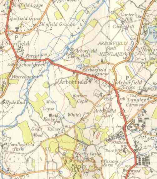 have exercised
the minds of the planners over many decades, and Arborfield's problems
were being considered even before World War 2. This article looks at
some schemes that eventually saw light of day, and many others that
didn't.
have exercised
the minds of the planners over many decades, and Arborfield's problems
were being considered even before World War 2. This article looks at
some schemes that eventually saw light of day, and many others that
didn't.
The Garrison was generating heavy traffic by the late
1930's; its main entrance was in Eversley Road, which was clearly
unsuitable for lorries. Berkshire County Council's Planning
Committee Minutes for January 1945 [Berkshire Record Office reference
C/CL/C3/21/1] reported as follows:
Reading – Eversley Road (A.327):
- Standard width: The County Surveyor reported that the
owners of the ‘Bramshill Hunt’ Public House proposed to
rebuild the premises, and before deciding on the site for a new
building, had asked for information about road improvements which the
Council contemplated carrying out in the future. There is an ‘S’ bend in
the road near the present public house, and in 1939 the Ministry of War
Transport approved a new 'middle of the road' line in order that the
road might be straightened out in the future. The Committee consider
that the Council should now adopt a standard width for this proposed
improvement based on the new middle of the road line which had already
been approved.
Recommended: That, in pursuance of Section 1 of the
Restriction of Ribbon Development Act, 1935, the Council do adopt a
standard width of 80 feet in respect of the section of the Reading –
Eversley Road (A.327) from the entrance to Targetts Farm, Arborfield,
southwards to a point 110 yards north of the southern boundary of
Martaix Farm, Finchampstead, in accordance with a plan prepared by
the County Surveyor.
- Construction of new length of road: - In view of the
importance of this road as a traffic route, the Committee considered
proposals of the County Surveyor for the improvement of other sections
of the road in the future. These proposals included provision being
made for (a) the length of new road about 1,266 yards in length
to the west of Arborfield Cross, and (b) another section of new
road about 2,600 yards in length, commencing at a point near
Arborfield Bridge, then northwards and joining the existing road at a
point near Ducketts Farm. This proposal would enable traffic to
avoid the narrow road through Shinfield Green and the built-up area
there.
Recommended: (a) That the line of the proposed sections of new
road, referred to above, as shown on the plans presented by the County
Surveyor, be approved. (b) That the East Berkshire Regional Planning
Committee be asked to make provision in their Town and Country Planning
Scheme for reserving the land which should be required for the sections
of new road; that pending the carrying out of the road-works the Interim
Development Authority be requested to refuse permission to develop on
the site of the proposed sections of new road, on the understanding that
any claims for compensation would be dealt with and settled by the
County Council.
By mid-1946, the Abercrombie Plan for Greater London
was being discussed by Berkshire County Council. Although its
proposal for a satellite town for White Waltham was strongly resisted,
the proposed New Town at Bracknell was embraced. At that time, it
was thought that around 25,000 people would be accommodated there, plus
around 5,000 in Wokingham. As it later turned out, Bracknell
Development Corporation attracted lots of Government funding and acted
as the overspill for Chiswick, Brentford and the surrounding area, while
Wokingham received no extra funding, but nevertheless became home for
many more than 5,000 people. Berkshire County Council started planning
for by-passes around all known pinch-points, and a long list was
presented to the Highways and Bridges Committee at its November 1946
meeting:
Appendix 4 to the Minutes of the Highways and Bridges
Committee
Report of Section appointed to consider proposals
relating to highways proposed to be included in Draft Town and Country
Planning Scheme (dated 5th July 1946) [Berkshire Record Office reference
C/CL/C3/2/20]
(All of the proposals subject to change)
[Items 1 to 16 covered roads in other parts of Berkshire and
the Vale of the White Horse, so not listed here]
17 Swallowfield, A.33. [details not recorded here, but similar to
the line of the by-pass constructed in the 1980's]
18 Shinfield. A by-pass of the Reading – Eversley Road (A.327)
commencing at a point north of the “Black Boy” Public House, proceeding
in a south-westerly direction to rejoin the Reading – Arborfield Road
(A.329 [sic]) at or near the River Loddon. This by-pass is necessary to
avoid a narrow and winding road through the village of Shinfield to
by-pass the junction at School Green.
19 Arborfield. A by-pass of the Reading – Eversley Road (A327)
commencing at a point west of Arborfield Cross to rejoin it at a point
to the south thereof. This is necessary in order to avoid development at
Arborfield.
20 Eversley: A by-pass of the Reading – Eversley Road (A.327)
commencing at a point to the north of the village and crossing the
County boundary to rejoin that road in Hampshire.
21 Wokingham:
(i) A by-pass to the north of the town commencing
at a point on the Forest Road, crossing the A321, proceeding eastwards
to join the road A.329, west of Popeswood.
(ii) A by-pass to the south of
the town by improving the route from Winnersh Cross-Roads via King
Street – Bearwood Road and Evendons Lane with a short section of new
road to connect with road A.321 at or near “The Throat”.
[Items 22 - 29 covered other parts of Berkshire, so not recorded here]
30 Trunk Roads – The Section have also considered long-term
proposals in respect of the following: -
London to South Wales Motor Road – This road will commence from
Maidenhead by-pass at a point west of road A.330 and proceed in a
south-westerly direction along a line which has not yet been definitely
fixed, running north of Wokingham, crossing A.321 in the parish of
St.
Nicholas, Hurst, A.329 in the parish of Winnersh, A.327 in the parish of
Shinfield, A.33 in the parish of Swallowfield, crossing the Great
Western railway line at Grazeley, through Burghfield, leaving the county
at Mortimer and re-entering the County in the parish of Aldermaston,
thereafter proceeding in a line generally westwards, south of Wasing and
Brimpton, leaving the County south of Brimpton, then proceeding south of
Crookham, Greenham Common, Newbury, cross A.34, A.343, running south of
Hamstead Marshall, Kintbury, north of Inkpen, crossing the road A.333
Hungerford – Salisbury Road and leaving the County south of Hungerford.
31 Winchester – Preston Road (A.34). [The suggested route is
close to the current line of the A34].
32 London – Bristol Road (A.4). [By-passes were described for the
following towns: Maidenhead, Theale, Thatcham, Newbury and
Hungerford.].
33 Maidenhead – Oxford Road. [There was a tentative proposal for a new
bridge north of Henley, to reconnect with the A423 at the top of
White
Hill].
The
January 1947 Minutes recorded:
Maidenhead By-Pass: The amended scheme provided
for a highway 109 feet wide with two 32-feet wide carriageways, a
15-feet central island and two 15-feet wide verges. The bridges of the
road would have a clear span of 89 feet. No provision would be made for
pedestrians or cyclists, except at the River Thames Bridge, where
footpaths and cycle tracks would be provided over the river bridge. […]

Over the years, more pressing problems occupied central
Government, and the Maidenhead By-Pass didn't get completed until
1959. Just as the population learned to 'make do and mend', so the local
authorities had to wait years for any major improvements to their roads,
by which time housing development had made several of the schemes listed
above impractical.
For many years, the A327 didn't even get a footpath along the Reading Road to the north
of the Cross, or the Eversley Road to the south,
despite continued pleas from Arborfield and
Newland Parish Council.
A fatal accident in early 1950 strengthened demands for
a footpath, but the most immediate result was that the southbound
bus-stop was moved to the Post Office where it has remained.
The by-pass for Arborfield Cross was later
abandoned after it was realised that significant traffic flows were
heading east of Arborfield to and from the
Motorway junction at
Winnersh.
However, Ministry of Defence plans for the Garrison meant that the
old Poperinghe  Barracks could be replaced, allowing a new
Garrison by-pass to be built to the
west of the 'Bramshill Hunt' P.H. Barracks could be replaced, allowing a new
Garrison by-pass to be built to the
west of the 'Bramshill Hunt' P.H.
The pub still stands on its
original site, though now heavily extended. The width of the road at
this point is still nowhere near 80 feet across!
Back to Properties Page
|
|
